Home
Mount St. Helens, Mount Adams [Gifford Pinchot National Forest]
Barnes and Noble
Mount St. Helens, Mount Adams [Gifford Pinchot National Forest]
Current price: $14.95
![Mount St. Helens, Mount Adams [Gifford Pinchot National Forest]](https://prodimage.images-bn.com/pimages/9781566955058_p0_v1_s600x595.jpg)
Barnes and Noble
Mount St. Helens, Mount Adams [Gifford Pinchot National Forest]
Current price: $14.95
Size: OS
Loading Inventory...
*Product information may vary - to confirm product availability, pricing, shipping and return information please contact Barnes and Noble
• Waterproof • Tear-Resistant • Topographic Map
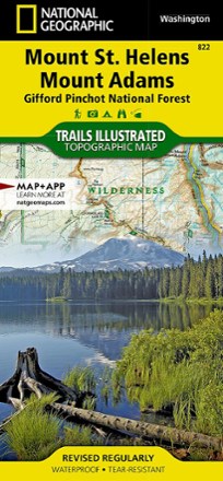
Mount St. Helens is an active volcano in Washington's Cascade Range. Neighboring peak Mount Adams is the second highest summit in Washington after Mount Ranier. Explore the beauty and geological wonder of these magnificent mountains with National Geographic's Trails Illustrated map of Mount St. Helens, Mount Adams. Created in partnership with local land management agencies, this expertly researched map features key areas of interest including Mount St. Helens National Volcanic Monument; Trapper Creek Wilderness; Swift Reservoir; Salmon, Cispus, and Lewis rivers; and Yale, Coldwater, and Spirit lakes.
This map can guide you off the beaten path and back again with miles of mapped trails including a portion of the Pacific Crest National Scenic Trail. Helpful information on Mount Margaret, Indian Heaven Wilderness, climbing Mount St. Helens, mountain safety tips and more will prove invaluable in your exploration of the region. Many recreation features are noted as well, including interpretive trails, campgrounds, ATV trails, sno-parks, cross country ski trails, and horse camps.
Every Trails Illustrated map is printed on "Backcountry Tough" waterproof, tear-resistant paper. A full UTM grid is printed on the map to aid with GPS navigation.
Other features found on this map include: Bare Mountain, Gifford Pinchot National Forest, Goat Rocks Wilderness, Indian Heaven Wilderness, Little Huckleberry Mountain, McCoy Peak, Mount Adams, Mount Adams Wilderness, Mount Saint Helens, Spirit Lake, Swift Reservoir, Trout Lake, Yale Lake.
Map Scale = 1:75,000
Sheet Size = 25.5" x 37.75"
Folded Size = 4.25" x 9.25"